

World → Europe → Alps → Haute Route
Click PLAY or watch a 1 minute preview on YouTube.
One of the best hikes in the world
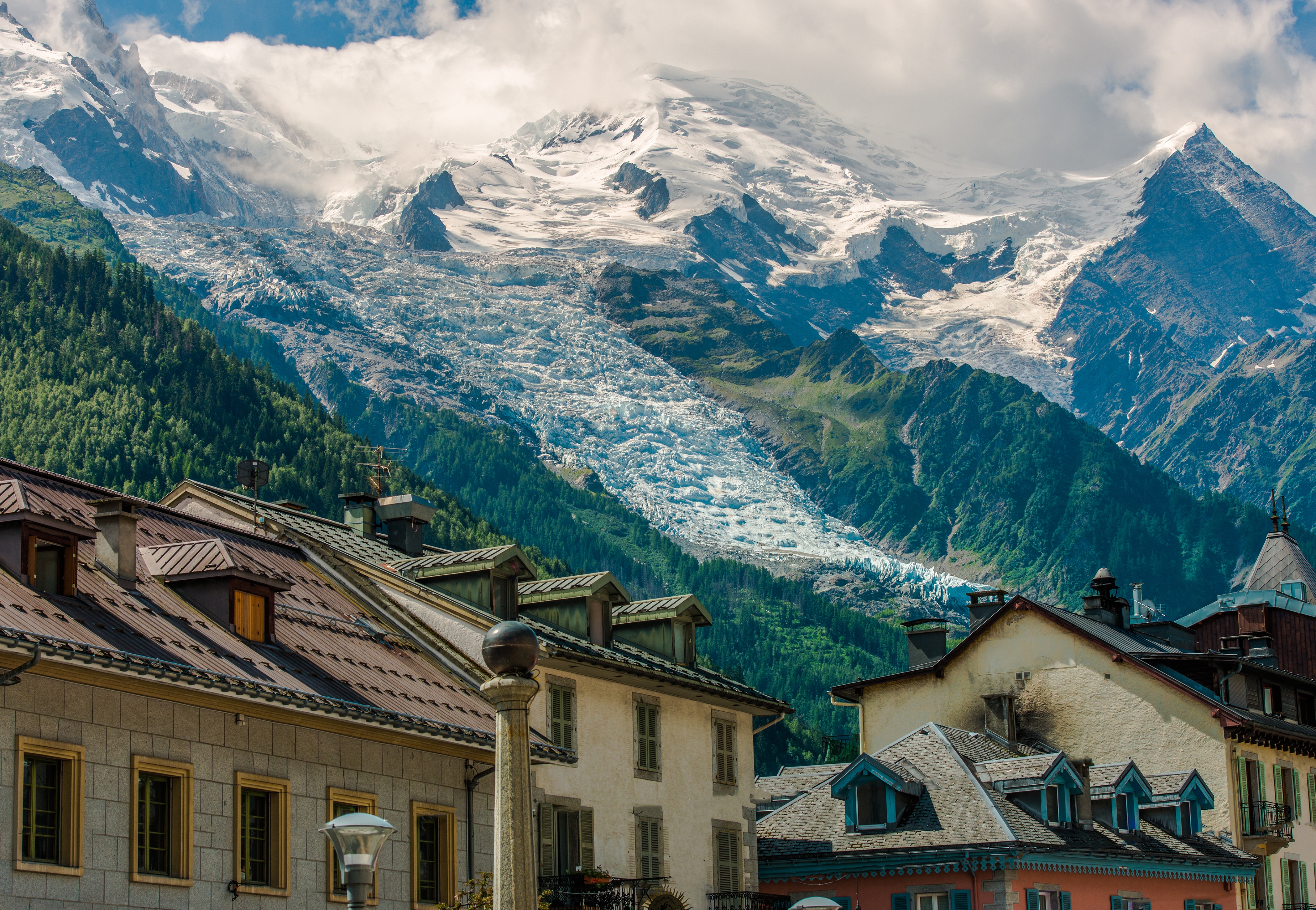
Chamonix-Zermatt Haute Route
Sometimes called …
- The Walker’s Haute Route
- “High Route”
- Mt Blanc to the Matterhorn
- Chamonix to Zermatt
Chamonix to Zermatt, Mont Blanc to the Matterhorn – in two weeks of mountain travel you will see the greatest collection of 4000 metre peaks in the Alps!

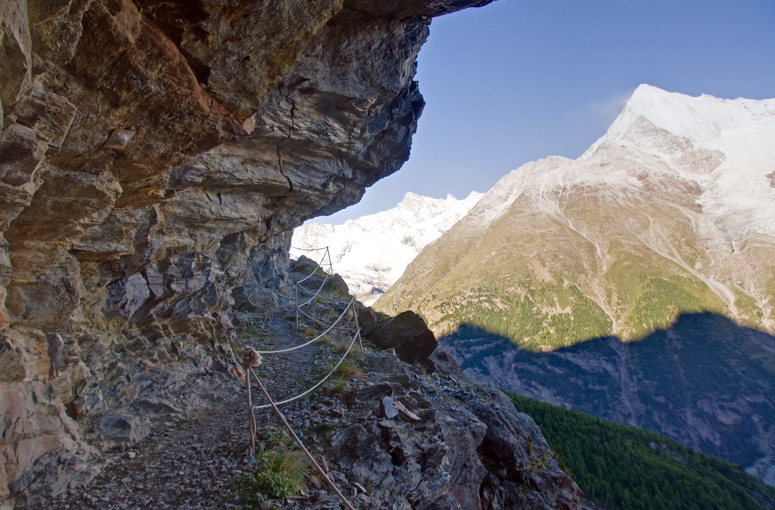
Matterhorn as seen from the end of the Haute Route
AT A GLANCE
- one of our top 10 hikes in the world
- the best hike in Europe!
- Alpine charm: valleys, lakes, glaciers
- great food, history, culture
- from Mont Blanc, the highest peak in Europe (4810m, 15,781ft)
- to the Matterhorn, the most beautiful peak in the alps
- 9-15 days
- 180+kms (112mi)
- best months June-Sept
- crosses 11 passes, gains more than 12,000m elevation
- difficult hiking

Why We Like This Hike
- in 2010 this hike replaced the more famous TMB (Tour de Mont Blanc) on our top 10 list
- the TMB is similar and excellent, but much more crowded than the Haute Route. As independent hikers, we don’t like mobs on the trail.
- the Haute Route is challenging, but with creature comforts en route


- by staying in huts (refuge in French, rifugio in Italian) and hostels (gîtes), and eating your meals there, you can hike with a very light pack


- frequent opportunities to buy food & supplies
- good trails
- good signage though you still need a map
- excellent guidebook by Kev Reynolds, the #1 trekking author in the world
- start in France, walk to Switzerland
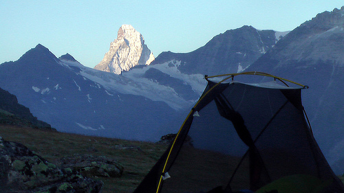
- you could carry your own tent, if you prefer, as wild camp tenting is not illegal in Switzerland (unfortunately it is illegal in France)
- almost certain to see ibex and chamois in the wild


- fantastic glacier views
- finishes with the 2-day Europaweg – a true high-level path opened in recent years (and sometimes closed due to avalanche)
- some mountaineers use this trek for altitude acclimatization, climbing Mt. Blanc, the Matterhorn or, best, Weisshorn, after they finish
Considerations
Rain is highly likely. Be ready for it.
- it can even snow on high passes any day of the year
- off-season footing can be treacherous. Crampons and ice axe may be useful, but it’s not likely you’ll need them.
- late afternoon dangerous thunderstorms possible
- mid-July through August accommodation may be full
- mountain huts can be crowded & noisy (we prefer tenting, to be truthful)
- iron ladders bolted into the mountain en route, though there is a way to bypass them
- cable-cars and chair-lifts are cheating, but you certainly may want to use them to shorten some hiking days (available June-Sept during daylight hours)
- German is the main language of the Haute Route though French is useful too. Anglophones may struggle.
- at times there are several different paths all heading the same direction. It can be confusing.
Routes
- most start and finish in Chamonix, one of our top 10 hiking towns in the world
- finish at the stunning Matterhorn above Zermatt
- get our recommended hiking guide book to decide how many days you wish to spend hiking
- check trip reports (bottom of this page) to get a feel for how much distance you will want to hike each day
Alpenwild recommends:
Day 1 – Travel to Chamonix
Day 2 – Chamonix to Trient
Day 3 – Trient to Champex
Day 4 – Champex to Verbier
Day 5 – Verbier to Cabane de Louvie
Day 6 – Cabane de Louvie to Prafleuri
Day 7 – Prafleuri to Arolla
Day 8 – Arolla to Les Haudères
Day 9 – Les Haudères to Grimentz
Day 10 – Grimentz to Zinal
Day 11 – Zinal to Gruben
Day 12 – Gruben to Zermatt
Day 13 – Zermatt
Day 14 – depart Zermatt
If you are looking for a short trip in the area, Andrew from Pygmy Elephant recommends just the Europa Way:
You can take a 20 minute train to St. Niklaus, then another 20 minute bus to Graechen. From there, you hike to the Europa Hut (about 10 miles) to spend the night. The next day, you can hike to Zermatt (about 12 miles). The views are spectacular, and you also get to cross the Charles Kuonen Suspension Bridge, the longest pedestrian hanging bridge in the Alps.

Cost
- in 2009 the cost for those organizing their own trek was around $70 / night for bed, bedding, breakfast and an evening meal
The Haute Route is not inexpensive. Compare your total cost against what you’d pay a trekking guide. (below)
Trekking Guides
Alpenwild is the largest tour operator leading this trek
Then compare what’s offered by the competition:
- Macs Adventure
- Wilderness Travel
- Bredeson Outdoor Adventures
- Mont Blanc Treks
- Alpine Interface
- On Top
- Mountain Madness
- Mountain Tracks
Increasingly popular are self-guided tours. A company organizes all your logistics, but you trek independently. A typical price for a self-guided Haute Route in 2013 was about $1800.
Haute Route SELF Guided Tours:
Logistics
If you sign on with a guided trip logistics will be organized for you. This section is for independent hikers. Like these.

First decision: do you want to stay in huts and gîtes, or carry your own tent & gear? (off-season some huts are closed so you may have no choice.)
Very, very few prefer carrying their own gear, including tent, to have more choices en route. Check the 2009 trip report by besthike editor Rick McCharles. He tented every night but one.
The biggest hassle with the Haute Route is getting reservations for accommodation. Especially if you don’t speak French or German. There is not yet any one place you can book everything independently for the entire tour. (This is one good reason to sign-on with a guided tour rather than hiking it independently.)
Many of the huts are privately owned. Membership in any organization is not required to use the huts, but discounts apply to some alpine club members.
Our advice is to book just your first few nights. As you hike, make a reservation at the next hut before you leave your current hut in the morning. The hut guardian will normally telephone ahead for you to confirm your next demi pension (bed, dinner and breakfast). This is risky as the hut you want next might be full — but it allows you much more freedom in your itinerary.
Most hikers in 2009 were calling ahead using their own mobile phone, a day or two in advance.
- the closest major airport is Geneva about 100km away
- the train to Chamonix is our favourite transport, but there are many other bus & shuttle options to get you there
- from Zermatt it’s easy to return to Chamonix by train, necessary if you’ve left any luggage at a hotel there
- some Swiss rail stations have luggage lockers, but there are none in France
ROUTES
- most start and finish in Chamonix, one of the great hiking centres of the world
- finish at the stunning Matterhorn
- get our recommended hiking guide book to decide how many days you wish to spend hiking
- checking trip reports (bottom of this page) is another excellent way to get a feel for how much distance you will want to hike each day
Local Information
- Chamonix.com – tourist information
- Zermatt.ch – tourist information
Best Trekking Guidebooks
- Cicerone Chamonix to Zermatt: The Walker’s Haute Route
- Trailblazer Walkers’ Haute Road: Mont Blanc to the Matterhorn – Alexander Stewart, 2008
- Cicerone Mont Blanc Walks – Hilary Sharp, 2005
- Au pays du Mont-Blanc: Balades pour petits et grands – Jean-Marc Lamory, 2003
There are many other good guidebooks, but English language speakers should use Cicerone. In recognition of all the good work done for us by Kev Reynolds over the decades. It’s as good as any other guidebook, certainly.
Lonely Planet provides a great overview of other options in the region.
- Lonely Planet Walking in the Alps – McCormack, et al., 2004 (no longer in print)
Best Travel Guidebooks
- Lonely Planet Europe On A Shoestring (out of print)
- Lonely Planet French: Phrasebook – Michael Janes
Of dozens of good options, we prefer Lonely Planet guides. Start with Europe, then search for the specific countries in which you are most interested.
Other Recommended Books
- Mont Blanc: discovery and Conquest of the Giant of the Alps – Stefano Ardito, 1997
- Savage Snows: The Story of Mont Blanc – Unsworth, 1986
- The Mont Blanc Massif: The 100 Finest Routes – Gaston Rebuffat , 1996
Best Maps
- Pays Swiss survey Landeskarte der Schweiz (LS or Carte nationale de la Suisse) 1:50:000 series (5 sheets) is recommended
- Kummerley + Frey single sheet 1:120,000
Most hikers shop the maps available in Chamonix once they arrive.
The maps in the Cicerone guidebook are enough so that you won’t get lost en route. (It’s not exactly wilderness.)
Best Web Pages
- Cicerone Trekking Chamonix to Zermatt
- TMBtent – Ultimate Guide to the Walker’s Haute Route
- Earth Trekkers
- Haute Route – Wikipedia
- chamonix.net – Haute Route
- Chamonix – Wikipedia
- Mont Blanc – Wikipedia
- tripadvisor Haute Route
Best Trip Reports
- Andrea Ference
- Travel 2 Walk segmented Walker’s Haute Route 2014
- Walker’s Haute Route: Unguided, Unmapped and with a Tent 2016
- Tom Dempsey
- David Galsworthy independently 2012
- Walking Womad 2014
- Mt Blanc to Matterhorn trip report & photos – besthike editor, Rick McCharles 2009. Solo and independent with tent.
- Haute Route – Pete Lockey, 2007
- The Hiking Life – Chamonix-Zermatt, France/Switzerland 2009
- StephAbegg – independent Haute Route, 2005
- Chamonix to Zermatt – Jed Micka, 2003
- Walkers’ Haute Route – Dave Mercer, 2001

Movies
Click PLAY or watch an Alpenwild promo video on YouTube. (guided)
Click PLAY or watch Kraig Adams (2025) on YouTube.
David Galsworthy and a friend did it independently in 2012, using Kev Reynolds. Click PLAY or watch his video trip report on YouTube.
Click PLAY or watch some drone footage on YouTube.
Click PLAY or watch Bob Keulers’ video including 3D maps.
Questions? Suggestions? Leave a comment on this page. Our editors will reply.

Thanks for the kind mention of me and my brothers trip report and YouTube video on the site. It is an amazing walk through the most wonderful scenery imaginable and justifiably gets a place in your top 10 walks of the world. I have also put a trip report and Youtube clip for another of your top Ten – the John Muir Trail on my Bigwalksclub website if you are interested. Kind regards and thanks for the great site – truly inspirational!
David Galsworthy
Thanks David. I added a link to your trip report on our JMT info page.
Rick Thanks a lot for putting the link on the jmt page – its great to share these amazing experiences with as many people as possible – keep up the great work on the site. Not certain what my next expedient will be – maybe the HRP in Spain in September. Got any suggestions from your favourite walks? Regards David
Any of the top 10 will not disappoint. 🙂
Dear,
Will surfing the internet and Google your site got my attention.
I have started a community about the Alps on http://www.thealpsforum.com and im looking for people who are willing to share the stories on my forum.
Maybe you have some nice stories to share on our community and of course promote your own site while writing your experiences.
I hope you can find some time for us and like our initiative, i really does like yours.
Best Regards,
Guido
Thanks Guido. I’ll check out your forum.
Its very hard to read your site with little dots floating down your page
Hi,
This rute looks beutiful, we have seen Ricks pictures and log of the trip. Afterwards we agreed that this is the rute we will go on, but first we have some questings about the hike.
My friend and I are planning to do this hiking in late July, and therfore we were wondering, what is the typical weather in the alps during sommertime?
We would like to go by tent, and camp outside, any tips and trick we should learn before travelling?
My friend and I are both in good shape but we have never tried to hike before, do you think it would be possible for us to even complete the hike?
Best Regards,
William and William
Go for it, William. This are is not wilderness. If you do have any problems you can easily escape to civilization.
My main tip would be to put up the tent right at dark in a quiet place. Wake up around dawn.
How do you think this would work in reverse, beginning in Switzerland and ending in Chamonix?
Just as good, I’d say.
Due to time constraints we are considering doing the route in sections and/or using lifts to gain altitude quickly. Can this be done? Suggestions please?
As I recall there are a couple of opportunities to take cable cars.
Cannot tell you any specifics, however.
Hey, thanks for the good info! I’m planning on making this trek this summer. I saw you had a page about tent camping on the Haute Route, but it only links to this page which doesn’t say much about tent camping on the trail. Any info you would like to pass on about camping vs. staying in the huts on the trail would be much appreciated. I’ve heard that wild camping is illegal (or looked down upon), or that it’s more accepted away from the towns… Any info that can clear that up would be much appreciated! Thank you!
I wild camped every night but one. My assumption was that all those locations were illegal.
But I set up my tent late. Took it down at first light. No problems.
Hi, I’m hiking the route solo in mid September and trying to get information about the Gasenried to Zermatt section via the Europa Hut. I’m having a hard time gaining information regarding trail conditions, etc. for that portion. Any insight?
Thanks,
Robert Ross
Bainbridge Island, WA
I only have a little time in France, and there are too many trails I want to hit. The Haute Route looks the most stunning, but I’m also one of those people who prefer solitude hiking. With my antisocial streak and limited time I think I’ll do a small (up to five day) section of the HR to get a taste and spend a bit longer on the gr5 and/or in the pyrenees.
Any recommendations on a 3-5 day section of the Haute Route?
Hey,
I only have 7-8 days and would like to do the Haute Route. What are some logical entry/exit points I could take? I will be travelling from Munich and need to go to Geneva afterward.
(Or perhaps there is a dull day or two I can skip with hitchhiking?)
Hi,
I am looking to do the hike this summer and I was wondering where I could find more information on the huts along the route or is it just easier to set up a tent after dark?
Thanks,
Chloe
Making reservations is no problem even if you don’t speak French or German. The accommodation you stayed at the previous night will book your next night. Also, any tourist office will book accommodation for you. Typically, a credit card is not required. BUT DO CANCEL IF YOU CHANGE YOUR PLANS. Not a bad idea to know enough French and German to make a reservation yourself. Even if the guardian doesn’t speak English, he will usually know a few words. Making a reservation should not be a problem with a little effort. This is a non-issue. You don’t need a guided tour!
Thanks Alpine!
hi, I would like to do the Walkers Haute Route IINVERSE! means starting in Zermatt and finishing in Chamonixx, in order to attemp Mont Blanc when I arrive there. I checked internet and bookstores but could not find any literature, any help? Thanks, Mingo
Sure. You can do that. Take any of the guidebooks and read the description in reverse.
My wife and I are planning the Haute walk. Is there a luggage transfer service between major towns/villages as on the TMB. cheers Des (Melb, Aust)
Is late September OK to travel the Haute trail?
I’m sure it is, Brent.
You will see some snow. Perhaps walk a few snow patches. But it should be great weather.
I had no problems making reservations at all recommended places to stay for my September 2018 Extended Haute Route with 3 days extra in Chamonix for acclimatization and 3 days extra in Zermatt to take in the scenery and use the cable car system. Made all reservations in January during off season. Will be hiking first 10 days alone to be joined by John and Paul L. in Arolla. Looking forward to make about 3000 pictures. Have been preparing for this trek in 2014, now it almost here, great anticipation.
Hi Wouter, maybe you receive this for the second time, but I was kicked out the site when sending. Hope you managed to go for the Haute Route in September. Was wondering if can give a short expression about it and maybe we can share some information about huts etc. as I want to go on my own in 2019.
Thx in advance.
Wim Boonstoppel
Yes, of course Wim, join us on Google Plus Arolla to Zermatt Half Haute Route which I will join my hiking partners half way
What places do you recommend staying in on the hike. Planning for this summer
You’d book huts (refuge in French, rifugio in Italian) and hostels (gîtes). Here’s what Alpenwild recommends:
Day 1 – Travel to Chamonix
Day 2 – Chamonix to Trient
Day 3 – Trient to Champex
Day 4 – Champex to Verbier
Day 5 – Verbier to Cabane de Louvie
Day 6 – Cabane de Louvie to Prafleuri
Day 7 – Prafleuri to Arolla
Day 8 – Arolla to Les Haudères
Day 9 – Les Haudères to Grimentz
Day 10 – Grimentz to Zinal
Day 11 – Zinal to Gruben
Day 12 – Gruben to Zermatt
Day 13 – Zermatt
Day 14 – depart Zermatt
https://www.alpenwild.com/trip/self-guided-haute-route/overview/
My favorite hut along the way is Cabane de Moiry. They have floor to ceiling windows and the view is onto the Moiry Glacier. It’s also a recently renovated hut, and they have smaller four person dormitories. The hike up is steep, but well worth it!
Hi
Yes recommend staying an extra day or 2 at both Chamonix and Zermatt. Both beautiful villages.
My wife and I did the later part of the Haute Route September 2019. Recommend staying at Arolla, Le Sage, Grimentz (beautiful swiss town), Zinal, Gruben, St Niklaus
cheers
Des Ryan
Hi, if we are starting out in Zermatt what do you think is the best 1 to 2 day hike in this route that we can do?
thank you!
emma
If you have the experience, I would hike the Europa Way. You can take a 20 minute train to St. Niklaus, then another 20 minute bus to Graechen. From there, you hike to the Europa Hut (about 10 miles) to spend the night. The next day, you can hike to Zermatt (about 12 miles). The views are spectacular, and you also get to cross the Charles Kuonen Suspension Bridge, the longest pedestrian hanging bridge in the world.
Thanks Andrew. The Europa Way is fantastic.
sorry per my request pls take into account it would be the end of february beginning of march. thank you!
I will probably never get to go there, but I thoroughly enjoyed your photos.
I did enjoy it for the 2 weeks of hiking with 3 days extra in Chamonix and 3 days in Zermatt. I call it the extended Haute Route. Planning my next trip once borders open